
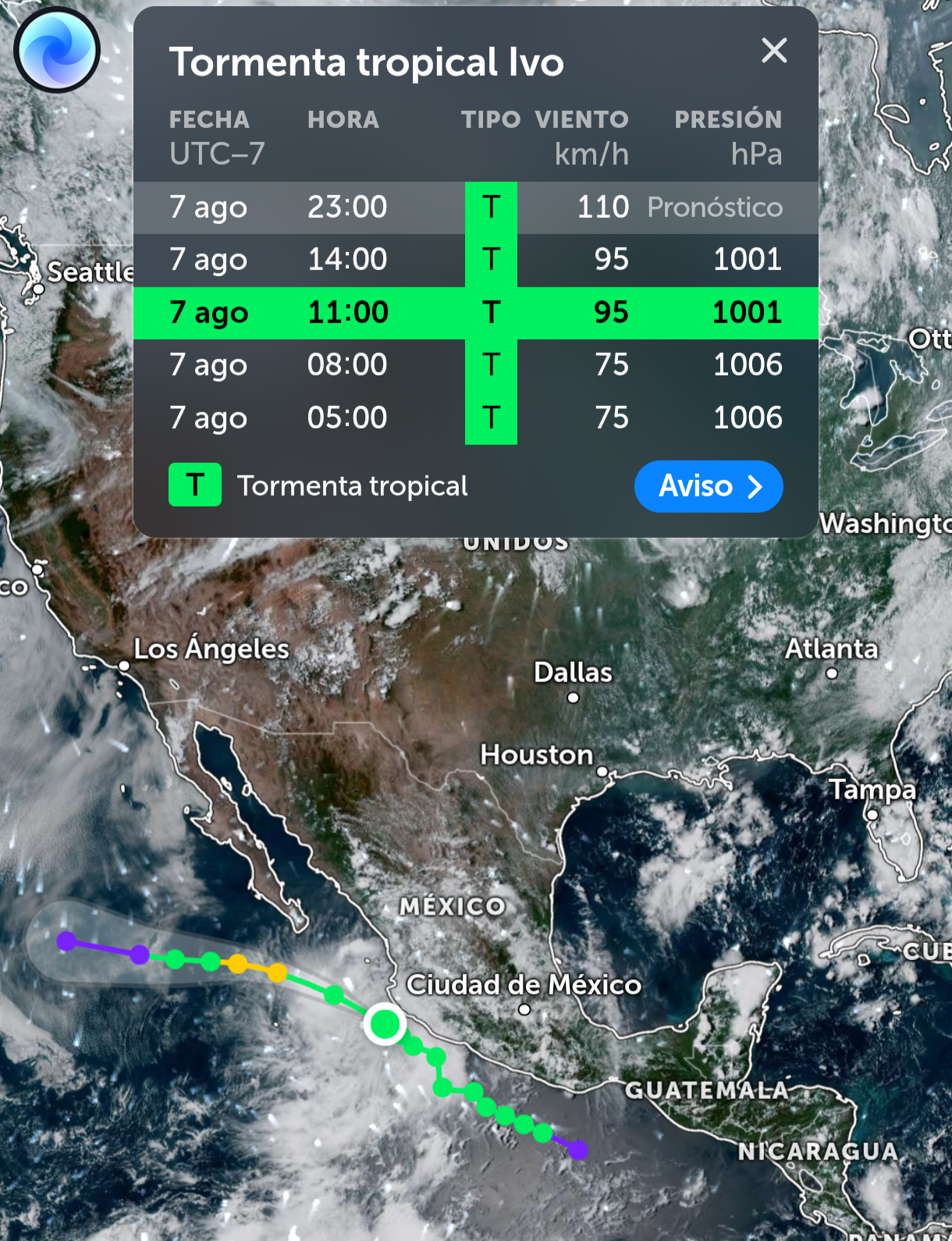
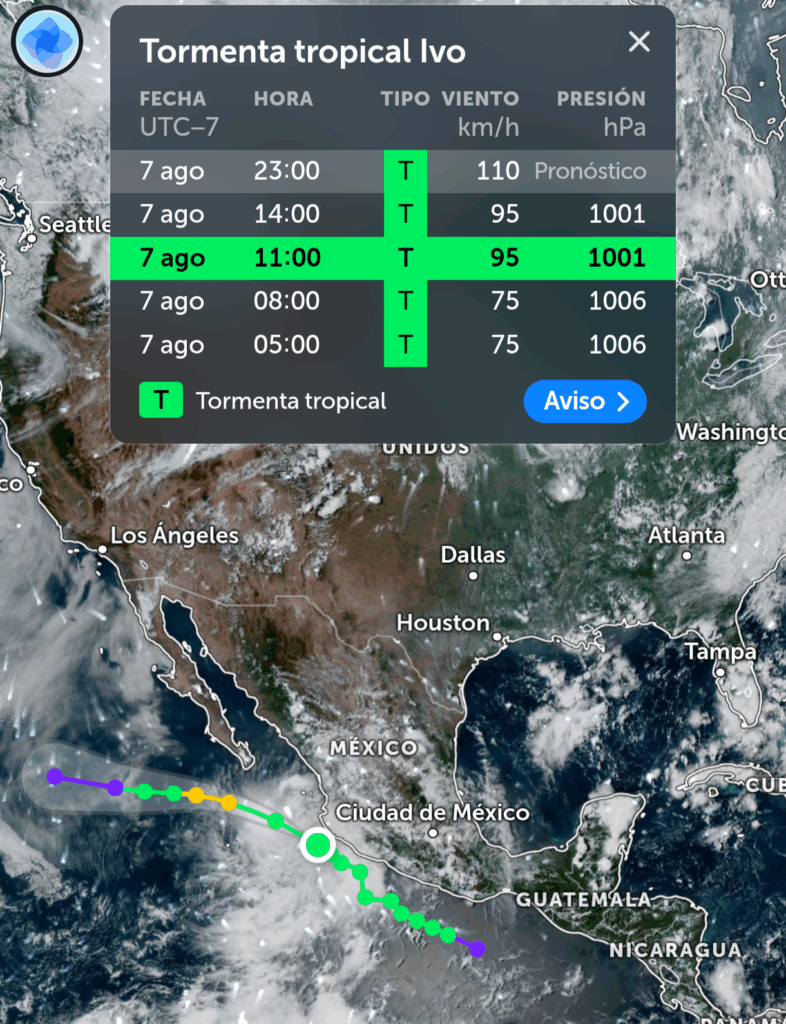
Pronóstico y evolución
- Conversión a huracán: Se espera que Ivo se intensifique a huracán categoría 1 en la escala Saffir-Simpson la tarde del viernes 8 de agosto de 2025, alrededor de las 18:00 horas, cuando se ubique aproximadamente a 240 km al suroeste de Cabo San Lucas, Baja California Sur. Sus vientos sostenidos podrían alcanzar entre 119 y 153 km/h.
- Trayectoria: Ivo no tocará tierra en México y se desplazará a lo largo de las costas del Pacífico, alejándose gradualmente del territorio nacional. Para el sábado 9 de agosto, podría debilitarse nuevamente a tormenta tropical, y el 11 de agosto se degradaría a una baja presión remanente en el océano.
- Impactos: Aunque no impactará directamente, su circulación ocasionará:
- Lluvias intensas (75 a 150 mm) en Jalisco, Guerrero y Oaxaca, y muy fuertes (50 a 75 mm) en Colima y Michoacán, con riesgo de inundaciones, deslaves y encharcamientos.
- Oleaje elevado de 3.0 a 4.0 metros en costas de Jalisco, Colima y Michoacán, y de 2.0 a 3.0 metros en Guerrero.
- Vientos fuertes con rachas de 50 a 70 km/h en las zonas costeras afectadas, con posibilidad de trombas marinas en Guerrero y Oaxaca.
Estados afectados
Los principales estados impactados por los efectos indirectos de Ivo serán:
- Guerrero: Lluvias torrenciales, oleaje elevado y vientos fuertes.
- Oaxaca: Lluvias intensas y riesgo de trombas marinas.
- Jalisco: Lluvias intensas y oleaje de 3.0 a 4.0 metros.
- Colima y Michoacán: Lluvias muy fuertes y oleaje elevado.
Recomendaciones
- Población: Mantenerse informada a través de los canales oficiales del SMN y Conagua, y seguir las indicaciones de Protección Civil. Extremar precauciones por lluvias, vientos y oleaje, especialmente en zonas bajas propensas a inundaciones o deslaves.
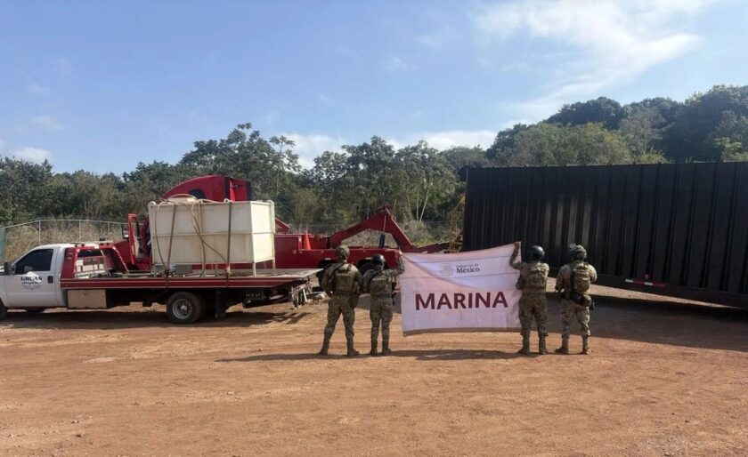
- Navegación marítima: La Secretaría de Marina (SEMAR) ha cerrado puertos en las zonas afectadas para garantizar la seguridad.
Contexto de la temporada
La temporada de huracanes 2025 en el Pacífico, que comenzó el 15 de mayo y termina el 30 de noviembre, ha registrado hasta ahora nueve ciclones: Alvin, Cosme, Dalila, Henriette, Ivo, y los huracanes Barbara, Erick, Flossie y Gil. Se pronostican entre 16 y 20 ciclones en total, de los cuales 8 a 11 podrían ser huracanes y 4 a 6 huracanes mayores (categoría 3 o superior).
Para más información, consulta los reportes oficiales en https://smn.conagua.gob.mx.
https://zoom.earth/storms/ivo-2025/#overlays=wind

Heya i’m for the first time here. I came across this board and I find It truly useful & it helped me out a lot. I hope to give something back and help others like you helped me.
I was examining some of your posts on this internet site and I conceive this internet site is very instructive! Keep on putting up.
Hey there I am so excited I found your web site, I really found you by mistake, while I was researching on Bing for something else, Anyhow I am here now and would just like to say thank you for a fantastic post and a all round exciting blog (I also love the theme/design), I don’t have time to browse it all at the moment but I have book-marked it and also added in your RSS feeds, so when I have time I will be back to read much more, Please do keep up the great work.
I’m extremely impressed with your writing skills and also with the layout on your blog. Is this a paid theme or did you customize it yourself? Anyway keep up the excellent quality writing, it’s rare to see a great blog like this one nowadays..
Your style is so unique compared to many other people. Thank you for publishing when you have the opportunity,Guess I will just make this bookmarked.2
You can definitely see your expertise within the paintings you write. The sector hopes for even more passionate writers like you who aren’t afraid to say how they believe. Always go after your heart. «We may pass violets looking for roses. We may pass contentment looking for victory.» by Bern Williams.
Hi there! This post couldn’t be written any better! Reading through this post reminds me of my previous room mate! He always kept talking about this. I will forward this article to him. Pretty sure he will have a good read. Thank you for sharing!
This blog is definitely rather handy since I’m at the moment creating an internet floral website – although I am only starting out therefore it’s really fairly small, nothing like this site. Can link to a few of the posts here as they are quite. Thanks much. Zoey Olsen
Perfect piece of work you have done, this site is really cool with great info .
Thanks for this terrific post, I am glad I observed this website on yahoo.
Hello my friend! I want to say that this article is amazing, great written and include almost all significant infos. I’d like to see more posts like this .
We absolutely love your blog and find a lot of your post’s to be precisely what I’m looking for. can you offer guest writers to write content for yourself? I wouldn’t mind creating a post or elaborating on a few of the subjects you write in relation to here. Again, awesome blog!
I have been examinating out a few of your articles and i must say pretty nice stuff. I will definitely bookmark your blog.
It?¦s actually a nice and useful piece of info. I am glad that you simply shared this useful info with us. Please stay us up to date like this. Thanks for sharing.
I do not even know the way I stopped up right here, but I believed this post used to be good. I don’t recognize who you’re but certainly you are going to a famous blogger for those who are not already 😉 Cheers!
It is in reality a great and useful piece of information. I’m satisfied that you shared this useful info with us. Please stay us up to date like this. Thanks for sharing.
I liked up to you will receive performed proper here. The comic strip is tasteful, your authored material stylish. nonetheless, you command get got an shakiness over that you want be handing over the following. unwell surely come more beforehand again since exactly the similar nearly very ceaselessly inside of case you defend this hike.
You actually make it seem so easy with your presentation but I find this topic to be really something which I think I would never understand. It seems too complex and extremely broad for me. I’m looking forward for your next post, I’ll try to get the hang of it!